It would be a shame to leave Montefiascone without recounting the amusing story of its most famous (some say undeserved )wine. Legend of Est! Est! Est!: The name originates from a story about a bibulous German prelate who sent his servant ahead to scout for good wines during his travels. The servant would mark promising taverns with “Est” (Latin for “it is”) on the door. If the wine was exceptionally good, he would write “Est! Est! Est!”. The bishop, impressed by the servant’s enthusiastic marking, embraced the wine and gave it the name. However,the priest took such a shine to it that he died from overconsumption; his pickled remains were laid to rest in the church of St Flávio.
Buona Salute!
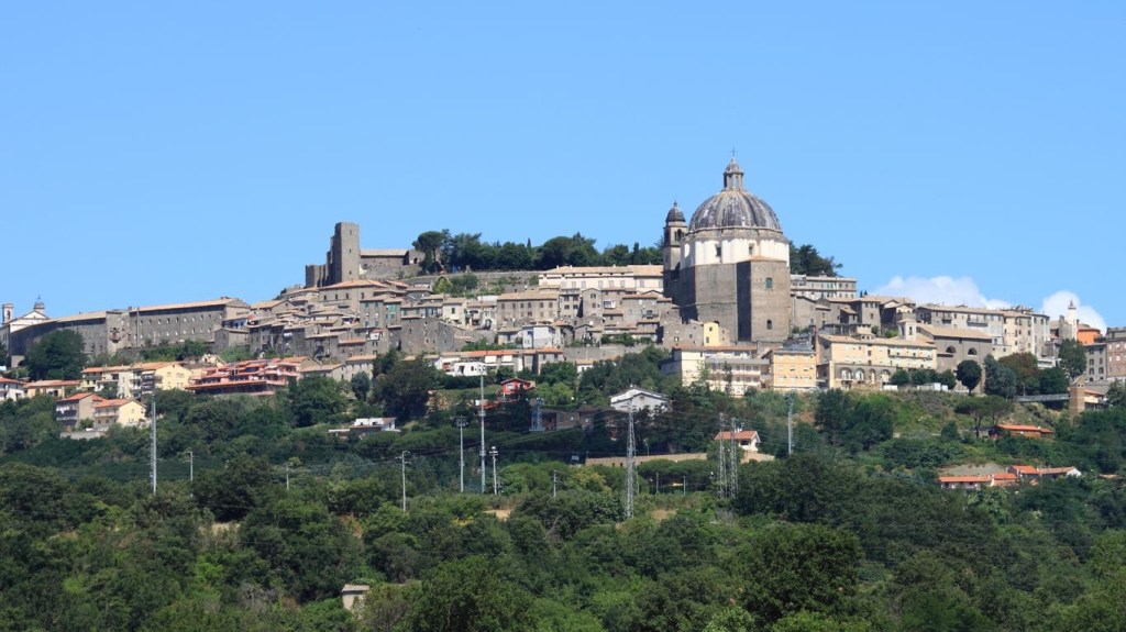
Cathedral of Santa Margherita, Montefiascone
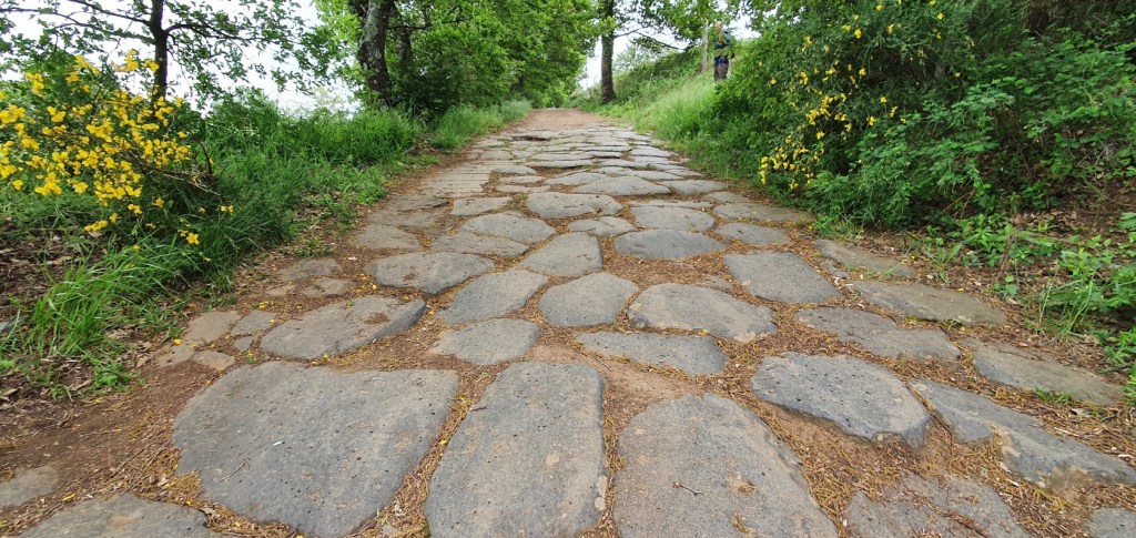
The first section of the route is spectacular, walking along the ancient paving of Via Cassia, still in good condition. Then a stretch across a hill track, overlooking lovely views of Montefiascone and Viterbo.
This way up to the start point of this sectionLooking back to Montefiascone – “ over my shoulder”.
The Roman road – The Via Cassia Antica is still in very good condition despite its 2000 years! Walk through history along these well preserved ancient Roman roads. The paving is still in very good condition thanks to the extraordinary road building skills of the ancient Romans. The ancient flagstones (basoli) are still sitting right where the Romans placed them.Montefiascone in the distance
We fork to the left hereabouts A welcome water fountain . We need to take plenty with us on this section.
We walk upwards for a while before descending through shade passing near a railway .
We fork to the right here and soon should see vistas of Viterbo nestled at the foot of a mountain. We follow signs, sending through flat fields to reach Parco Terme Bagnaccio and its famous hot springs. There should be a kiosk open here for refreshments.Pilgrims have traditionally been welcomed here for centuries
Not far to Viterbo along a gravel road,passing the airport the route becomes a bleak panoply of suburban auto businesses interspersed with tall, concrete retaining walls – the entrails of the city. But not to despair as finally arrive at the Porta Florentina from whence we head straight downhill on cobblestones to the end of Via Matteoti and then the Corso Italia to reach Piazza Plebiscito
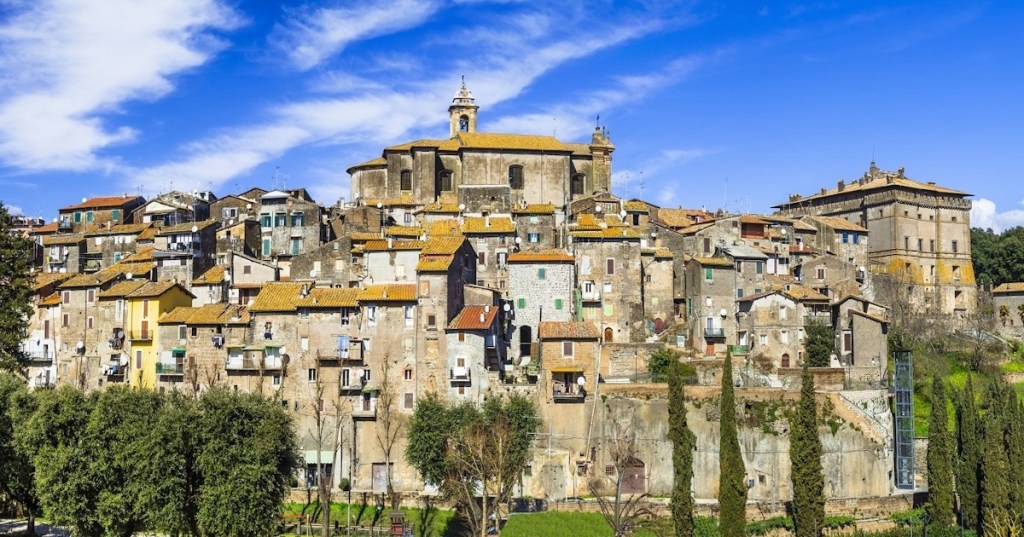
Apparently the “ gritty” entry into Viterbo can give the wrong impression of what is an otherwise charming and historic city,whose existence dates to an era long before Rome. Viterbo is the centre of the Tusca region of Etruscan culture (9th – 4th C b.c ) whose vestiges and influences are still quite visible. The city has an eventful history and a great richness of architecture which we shall have time to explore as we have a full day’s respite here.
Hotel Palazzio Riario, via Della Torre,17 ViterboBreakfast is served.
“Nice hotel. Comfortable, clean, beautiful room in an old house. The owner of the hotel is very nice and friendly, in touch if necessary. Arrived later than the appointed time, checked in very quickly. Location in the very center of the city. Everything is within walking distance. Nearby, a couple of minutes walk, there is even a small supermarket, which is very convenient! Very happy with the choice!” RECENT REVIEW.
Total ascent 638 m.total descent 356 m NB There are no services until MONTEFIASCONE, we shall need to bring snacks and additional water.
Until the last few busy km into Montefiascone the stage is full of serenity and calm. Gravel roads and paths among fields and forests with occasional views of the lake. A couple of limbs of 50-150m.
Rome is 70 miles away. Leaving the Piazza S. Cristina, we pass through the Porta Romana and take the Via IV Novembre. Walk about 200 yards and turn left at the crossroads along the Via Acqua della Croce. It is wiser to buy bottled water than to fill our water bottle at the small fountain or at least it is advisable to inquire about the quality of drinking water in each of the towns through which you pass. Another 100 yards and we turn right into the Via Bartolomeo Bocchini and fork left into the Via Caio Rufo Musonio, named after a philosopher from Bolsena. There is a slightly shorter distance to cover for walkers than cyclists because of the one-way system. There is a uphill stretch at the end of the street. You follow the signpost for the Agriturismo Le Vigne for a short distance. A further hundred yards and the tarmac road gives way to an unpaved track on your right.
All Trails view.
We shall be walking in the territory of Tuscia, named so because of the Etruscans, who lived in this area (even though Tuscia used to be much wider than this) before the Romans.
There are also many shady stretches.
“Follow the power line and the blackberry bushes for two hundred yards and turn right again close to an electricity box where you can see the red and white “F” and a multitude of other signs.
There is a trough of running water at this point where someone has painted a red “X” as an additional warning not to drink the water. You have to leap or ride across a stream on your right.
Walk uphill for four hundred yards and go down the cement road on your right; a beautiful view of the Lake.
Straight afterwards, at the fork in the road, take the road on your left. A tarmac road leads you to the house with the animals.
Three hundred yards ahead, opposite a private property, continue along a narrow path running alongside it on your left, (take care not to fall into the ditch on your left, half-hidden by the vegetation). Poultry and black pigs.
The house at the end of the narrow path is more elegant.
Walk down as far as the fountain. Four hundred yards and you arrive at a junction where four roads intersect, take the asphalt road in front of you, bearing left.
If you continue straight ahead and downhill, a cross on a post quickly tells you that, on leaving the gravel track, you should have turned left along the tarmac road.
There are enough signs inviting you to bear left.
Follow the power lines for a lot of the way.
Continue walking past a large number of houses, not taking any minor road or track on either side, until you reach a wide green barrier.
There are plenty of signs along the way.
The path after the wide green barrier winds fairly smoothly until you reach a fairly steep uphill stretch.
Leaving the asphalt behind you, you go up to a beautiful low plateau. There are caves (or tombs?) used as garages for farm vehicles.
The walk between Bolseno and the Parco di Turano is indeed very beautiful, only interrupted by small groups of houses. You are on the Monti Volsinii. Excavations are taking place on the nearby Monte Landro where an Etruscan temple has been discovered.
Another cave where building work has been done at different periods to support the entrance arch.
Other caves.
In the past, water trickling through the mountain used to be collected in stone basins or open pools and used for irrigation purposes. A project was funded some years ago in Bolsena and Montefiascone to restore some of them.
Your uphill walk comes to an end and a sign invites you to turn right across the grassland.
That’s right, turn right.
Walk in the hot sun.
It is a beautiful walk between Bolsena and Montefiascone, but it is worth checking the temperature before setting out and being prepared.
The route is well signposted.
At various stages, you catch glimpses of the town of Montefiascone or Bisentina Island.
You cross a dry ford depending on the time of the year.
There is only one isolated house along this stretch of the Via Francigena.
You will soon arrive at another low green barrier.
Cyclists should take care. There is a very inviting downhill ride.
Another mile or so of an enjoyable downhill walk with a splendid view of the Lake, your feet touch the asphalt again and you turn left uphill.
The route is signposted often …
… and in many different ways.
You follow the Via Francigena signpost.
The path leads you between olive groves and vines and rows of vines between olive groves.
The next Via Francigena signpost and the directions for the Bosco di Turona.
The Bosco di Turona is an area of picnics and springs. There is a picnic area with tables before you reach the glade with the chapel and there are tables near the chapel. Turn right at the fork in the road indicated by a Via Francigena signpost.
Signs also indicate the spring, Sorgente di Turona, (1908). Local hunters drink at the spring and so do we.
Just before you reach a small chapel dedicated to the Virgin (and seemingly vandalised), you leave the main track and turn left up an unpaved road.
In September, after the first storms, the torrential rain has cut deep channels in this section of the track and in the approaching downhill path.
Walk another four hundred yards and then take care.
A track goes downhill on your right and is only indicated by arrows and other signs left by pilgrims and walkers.
The channel cut by stormwater makes the descent difficult.
The path goes down to the Fosso d’Arlena (stream).
You ford across the brook and it is sometimes difficult not to get your feet wet. Not everybody is as nimble as we are and it is even more difficult with a bicycle. It is sometimes best to take your shoes and socks off. You enter the wood and turn right uphill. The path is well indicated by white and yellow arrows. For a part of the journey, you can still hear the murmur of the Arlena stream down below.
The path winds steeply up and bears left.
You finally come out into the open countryside with beautiful views of the nearby lake.
The path widens and the slopes are more gentle with the path running alongside vineyards. Milestones reassure you that you are on the right track.
You will notice the first stones of the ancient Cassia.
The route is indicated by familiar Via Francigena signs, increasingly familiar milestones and a myriad of arrows, symbols and stickers.
At a junction where four roads intersect, you can choose to take the unpaved road on your right and ignore the signs for a stretch of asphalt road. The track seems to end near a country house. You may be crossing private property. Continue leftwards alongside a field on your right down an unpaved road. You arrive back on the asphalt and turn right towards the Cassia; you reach the Cassia after 50 yards and turn left towards Montefiascone. If you do decide to follow the “official” route, take the tarmac road on your right and turn left when you reach the Cassia. Another 900 yards or so and you leave the Cassia and turn left.
Keep straight on ignoring the tracks on either side.
This stretch is uphill but not steep and bordered on your left by vineyards and olive groves.
The track starts as a dirt track and then a road which no longer seems to be maintained and another mile or so and you are back on a macadamised road.
You arrive at a busier asphalt road at the entrance to Montefiascone and you turn right. Turn left when you reach the Cassia again. Follow the Via Cardinale Salotti. If you wish to visit the Santuario della Madonna delle Grazie, you can make a detour along the Via S. Maria delle Grazie which joins the main Orvieto-Viterbo road (S.P. UMBRO CASENTINESE). Turn left when you reach the main road and walk a short distance until you reach the Sanctuary. After your visit, follow the main road back into town. Otherwise continue along the Via Cardinale Salotti until you reach the main Orvieto-Viterbo road (S.P. UMBRO CASENTINESE). A little farther along, on your right, you pass in front of the magnificent Church of St Flavian ( S. Flaviano), always open and well worth a visit.
The next stretch of the Via Francigena starts on the Via Cassia again. To enter the town, take a narrow road on your right after the Basilica di San Flaviano. After the Piazzale Roma, take the Corso Cavour as far as the Piazza V. Emanuele. You can visit the Chiesa di Sant’Andrea, the Cattedrale di Santa Margherita and La Rocca dei Papi (Papal Fortress).” The above somewhat lengthy descriptions I found on a Blog called MY FAVOURITE NECROPOLIS
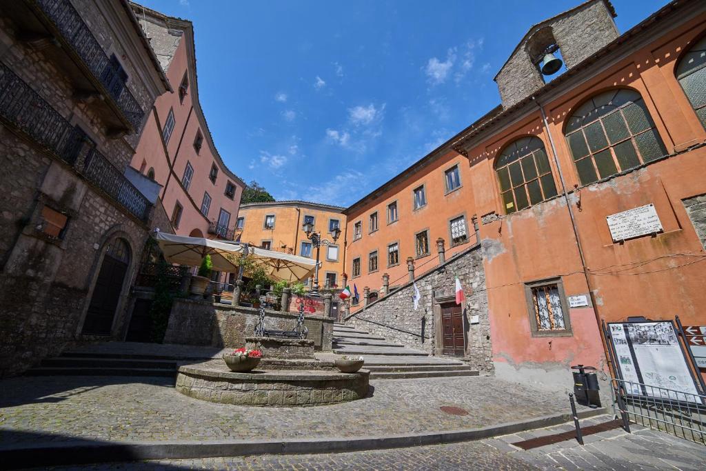
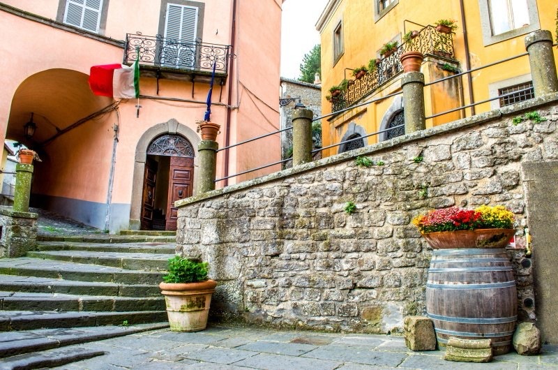
60 miles in old money, to Rome.Montefiascone has a reputation for welcoming Pilgrims.Uphill to the town Centro Storico
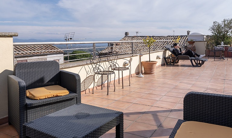
Rooftop view. “Stayed one night on the Via Francigena. Room was clean, quiet and staff helpful. Breakfast good and location can’t be beat at the top of the town within easy walking distance of all the sights. Half board arranged at restaurants Dante alegheria. Food was fine and a great people watching experience”. A RECENT REVIEW
Fairly flat terrain- 23% on pavements San Lorenzo is the only stopover on this section.Today, we make our way to Bolsena and its renown volcanic lake. One of our party will be intrigued by the fact the the town’s patron Saint is Santa Cristina,feast day,24 th July.On her feast day,the townspeople act out the lurid scenes depicting the multiple tortures she suffered under the Romans – no one seems particularly worried that the episodes don’t tally with any known historical facts!
There is only one place for re-filling water bottles and refreshments today, so we need to be prepared.
Maybe not quite that much.A shady start
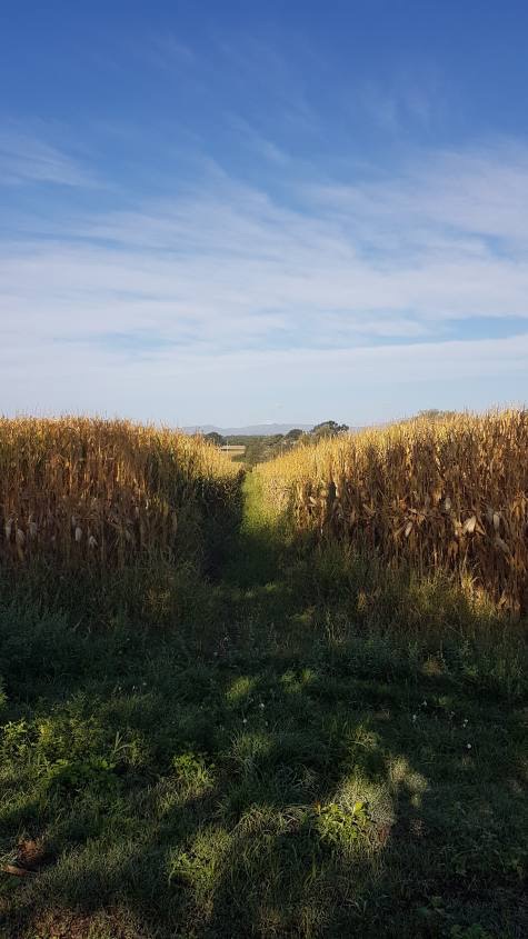
Almost immediately after leaving the city, a part of the route begins along a dirt road that passes through some crops. We are at a low altitude and from here we shall only see the cultivated fields. There are no sunflower or wheat crops to make everything a little more picturesque, but there is no shortage of tall corn plants. They are very tall .
Blue skies though .
The initial stretch is not that remarkable but in less than three hours, precisely halfway along the route, we shall reach the first town of the day and everything begins to have a different aspect . San Lorenzo Nuovo and here to welcome us there is a beautiful octagonal square, called Piazza Europa, which looks pleasantly impressive.
Famous Octagonal Square
San Lorenzo Nuovo is a village located on the northern side of the Volsini mountains just five kilometers from the shores of Lake Bolsena. This country is located in a particular geographical position that places it on the border of three regions: Umbria, Tuscany and Lazio. San Lorenzo Nuovo, as its name suggests, arose in recent times unlike other villages and cities in this area. The town was founded in 1779 by the inhabitants of San Lorenzo alle Grotte,which had to move due to the presence of malaria-carrying swamps which made the air unhealthy. The historic center of the village is of a neoclassical style dating back to 700. The city has a particular urban structure made up of a series of houses that follow the octagonal shape of piazza Europa the city center where the church of San Lorenzo stands. It might come as surprise to learn that the principal crop hereabouts is the humble potato.
Church of San Lorenzo A wooden crucifix (a work from the early 14th century attributed by some to Maitani) and two paintings by Jacopo Zucchi.
Look out onto the road that continues at the end of Piazza Europa to glimpse Lake Bolsena in all its splendor.
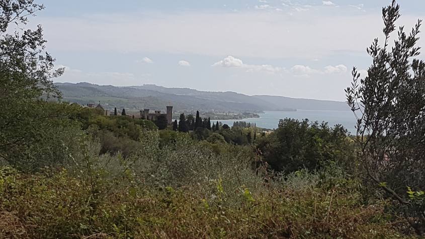
This is Piazza Europa, that blue in the distance is the Lake. Our first encounter with Bolsena! At a 114km2, Lago di Bolsena is Europe’s largest volcanic lake. Between 100,000 and 200,000 years ago successive volcanic eruptions led to the collapse of the earth’s crust in the volcano’s caldera for in the lake and its two islands. Underground springs and storm water runoff fill the lake,which has an outlet to the sea through the Marta River.
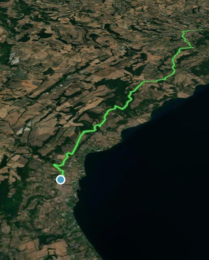
Up to Bolsena, the route continues on dirt roads in a pleasant up and down that sees alternating olive groves, meadows and woods. The characteristic that these different landscapes have in common are the fantastic views of the lake that can be glimpsed every now and then. It is a very beautiful section.
And with a body of water on the horizon, any glimpse will be definitely worth a little stop.Onwards through a woodland section Bolsena in the distance. Ancient streetsThe sun kissed lake – anyone for a dip?
WHAT TO SEE IN BOLSENA.
Take a tour of the delightful historic centre. “Among the places of greatest interest we will find the “Collegiata di Santa Cristina”, built in Romanesque style and later restored with the addition of the beautiful Renaissance style façade. The Collegiata is best known for the Miracle of Corpus Domini.I refer you to the very well-kept blog “Itinerari Laziali” to learn in detail the history of the miracles of Santa Cristina. In the upper part of the town the “Church of San Salvatore” and the “Castello Rocca Monaldeschi” (which we have already encountered as soon as we entered the town) dominate the landscape. The entrance ticket to the Castle costs only €5 and allows you to visit the Territorial Museum of Lake Bolsena, the towers with a view of the lake and the Aquarium. If this is not enough for you, there is an immense lake with its shores that are just waiting for your visit.”
Santa Cristina – it was here in 1263,while a priest who doubted the concept of transubstantiation was consecrating the host, the bread he was blessing suddenly began to drip blood onto his hands and the cloth below. In response,the following year Pope Urban IV creathed the feast of Corpus Christi,now celebrated in Catholic Churches throughout the world. The miracle,along with the relics of 3rd c. martyr Santa Cristina made Bolsena a prime pilgrimage destination in its own right.The castle.These posters are ubiquitous and very tempting,too.
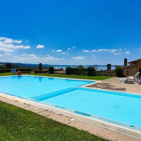
If the lake doesn’t tempt you to swim then possibly the pool at tonight’s Agriturismo will.
A view from Agriturismo Le Vigne,Via dell Vigne,Bolsena. “Nice big room and bathroom ⅊You can use the garden everyone has their place in front of the rooms Good breakfast with lots of choice Very clean Great location you can see on the Bolsena lake Located on Via Francigena” Review from October 2024